Traffic and parking have become troublesome issues for motorists in many cities and the impact of these growing problems on buyers, particularly younger ones, is a rising concern for carmakers.
The issues are also attracting the attention of technology companies.

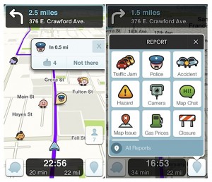
The city of Boston, in an effort to curb the problems created by double parking on the city’s narrow streets, has teamed up with Waze, an app-based GPS system that provides real-time traffic updates from users.
Besides helping commuters navigate city traffic, Waze data is now helping Boston target that most annoying source of slowdowns – the double-parked car.
A team from the city’s Transportation Department, the Department of Information Technology and Boston’s New Urban Mechanics group looked at three months’ worth of citizen-reported data from Waze to find streets most likely to have double-parked and illegally standing cars.
When the team identified those streets with the most illegal parking – around Fenway, Boston Medical Center and Longwood – additional bike-riding parking enforcement officers were deployed to those areas to get the double-parked cars to move, according to Peter Ganong, a member of the citywide analytics team.
(Americans failing to take advantage of shopping for car insurance discounts. For more, Click Here.)
“Double parking isn’t just annoying, but it also creates congestion and potential safety concerns for cyclists and pedestrians,” said Greg Rooney, director of parking management, in a YouTube video. “It’s important just to keep traffic flowing, for public safety reasons and just for quality of life.”
The city has been sharing real-time traffic data with Waze since Mayor Martin Walsh announced the collaboration in February.
The partnership has allowed Boston’s more than 400,000 Waze users to see up-to-date traffic conditions like accident reports, road closures and potholes, and provide the Boston Traffic Management Center with information like traffic speed data that can be used to improve traffic signal coordination.
(Click Here for details about TDB’s first drive in the 2016 Hyundai Tucson.)
Meanwhile, a city in Germany is experimenting with a new system that directs motorists to a specific parking place.
The city of Bergisch-Gladbach, Germany, in an effort to achieve a more efficient usage of the existing parking in the city has tied eight of its parking lots into a dynamic parking system, which features an open parking capability to detect vehicles entering and leaving cars via video technology.
(To see more about Tesla moving from “insane” to “ludicrous” with the Model S, Click Here.)
The system also includes 29 LCD variable message signs, five of which feature two-line information displays to display local event information. Swarco hosts and operates the server in its computer center and city employees connect to the system via mobile GPRS communication between the parking guidance computer, the signs and the parking facilities.





It should be a no brainer to use automated tech to determine real time available parking in the various lots and make that info. available to anyone using GPS – for free, as they do weather and highway safety info. via radio and GPS in Germany.